NolaCycle is a project aimed to create a high quality cycling map of New Orleans. Cycling maps include information beyond just streets and their names that benefits cyclists. In our map, we highlight the pavement quality, car travel speed, lane width, and special caution areas (busy intersections, man-eating potholes, or high accident areas). Volunteers help to collect this data by attending mapping events.
The information is then digitized to make a map of the data we collected to help cyclists - young, old, local, and tourist alike - navigate New Orleans.

Check out the blog for updates on the project, ways to get involved, and volunteer mapping events!

If you have questions, feel free to make a public comment on the blog entry or e-mail us directly at info@nolacycle.com.

Monday, May 31, 2010

Critical Mass: victory. Dead Pelicans Ride Monday 5pm Jackson Sq

Thanks corkers! Thanks everyone! an amazingly fun ride, yeah.


150 in number, we rode down canal to the cheers of onlookers. After one hiccup at City Park Ave, we strolled down Metairie Rd, broke, then took a left on Airline.

Because of a slight miscommunication, we ended up on the original route, Shrewsbury. which unfortunately is only formerly a street. (apologies to the woman who told me we weren't going to Central. you were right.) The sight of all those bikes portaging over the tracks is a memorable one, and unfortunately a practice required too often for cyclists in JP.


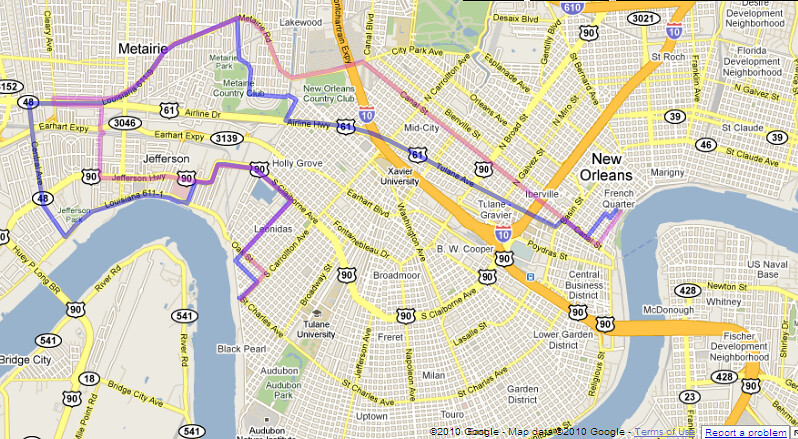
we did manage to lose our police escort at this point, only to be rejoined as we turned onto Jeff Hwy and back home via Leonidas. Jeff Parish was slightly more aggressive, but only to clear one lane of three. well, we can give them a lane.

The Dead Pelicans ride 5pm tomorrow. Dress Black, Ride Slow
-anyone have a mobile drum?

Kat is taking route suggestions. meet early, 4:30pm to talk routes.

This is only a beginning. the oil gusher won't end until the relief wells are done, probably around August. bigger and better, onward and upward.

So what are we doing for June? How can we support the demands of our rally? let's get together for planning and to contact media.

June 9th Rue on Oak and Carrollton 6:30pm
June 10th Sound Cafe 6:30pm

think floats.

ride safe!

scott


#######################

OUR DEMANDS

This a list of ten demands we are making of the federal government.

Note we are speaking to the federal government, NOT BP. BP’s chance to have any say or authority in this process should be long past. BP has proven itself a criminal enterprise concerned only with profit, recklessly and indifferently murdering its employees and the entire Gulf coast.

We demand the Federal Government intervene immediately to stop the BP Oil Flood and:

1. Declare the BP Oil Flood a national disaster so that Louisiana can finally begin getting federal assistance.

2. Stop BP’s use of “Corexit” and other chemical dispersants that present significant danger to health and safety.

3. Under a state of emergency, employ all resources (including Navy) of the government at every level – Federal, State, local, and parish — to defend our coast, our livelihoods, and our culture.

4. Suspend all BP contracts by means of the EPA’s discretionary debarment act and seize all of BP’s assets, including BP Atlantis and other operational offshore rigs, to assure that all costs of cleanup and remediation are covered.

5. Strongly enforce all regulations for workplace health and safety:
Cleanup crews must be supplied with and allowed to use full-face respirators, not paper masks.

6. Undertake immediate, full, and ongoing 3rd-party verified air-quality and toxicity testing in all affected areas, including New Orleans, and objective close monitoring of the oil leak to determine the true extent of the catastrophe.

7. End all deepwater offshore oil drilling.

8. Institute a temporary moratorium on non-deepwater offshore drilling (both current and new operations) and require each operation pass a stringent independent safety review before they can resume operation. Those that fail inspection stay shut down and are heavily fined until they comply or are debarred.

9. Keep all lawsuits related to the BP Oil Flood and its aftermath in Louisiana, and instruct the DOJ and States’ Attorney General to hold BP, Halliburton and Transocean accountable to the furthest extent possible under the law.

10. Found a two-decade TVA-Style Gulf Coast Authority that rebuilds sea walls, levees, coastlines, and wetlands, with a dedicated fund for fishermen and related industries to provide economic relief for those put out of work because of the disaster.

Tuesday, May 25, 2010

Street Bucklin' Heat, Y'all

From the nola.com feed:
http://www.nola.com/traffic/index.ssf/2010/05/five_kenner_streets_buckle_in_intense_heat.html

one wonders why we pave the GMO with materials that can't withstand the environment and compact the soil.

By Mary Sparacello, The Times-Picayune

May 25, 2010, 5:13PM

road_work.JPGAt least five locations on Kenner streets have buckled during the hot temperatures of the past four days, City Hall said Tuesday.

The Public Works Department said streets failed at:

-- 1500 38th St. near Greenlawn Terrace Elementary School
-- 661 Mayfair St. in the Holly Heights subdivision
-- 3600 Loyola Drive in University City
-- 3419 Florida Ave. in Greenlawn Terrace
-- 2400 Tifton St. in Veterans Heights.

Sunday, May 23, 2010

Banner Making this Tuesday 7pm @Nowe Miasto

No need to Drill, no need to Spill or Kill:

let's make Banners, to help set the tone for our ride this Friday, May 28th, 6pm.

We are meeting at Nowe Miasto, at the end of Jane Place, off Broad and Banks in MidCity. The time is 7pm Tuesday, the 25th.

Please bring

Bamboo
craft wire
Old Campaign Signs
White Bedsheets
Paint
Markers

or any materials that will help us construct mobile signage.

see you there!
scott
scott@nolacycle.com

Friday, May 21, 2010

TOMORROW (SATURDAY) - ANNUAL BICYCLE SECOND LINE PARADE!!!!

Twitter @mbcnola, #Bike2ndLine
---------------------------------------
http://www.mbcnola.org/SecondLine.html

WHAT: 2010 Bicycle Second-Line

WHO: Featuring the Crescent City Stompers

WHEN: Saturday, May 22nd, 2010 formation at 10:00am; departure at 10:30am

WHERE: Commencement at Magazine Street and Zoo Drive; After party at Avenger Field (Tchoupitoulas and Exposition Blvd.)


View Bicycle Second Line in a larger map

WHY: To show cycling enthusiasm for New Orleans, and learn about cycling improvements in the city

WITH: New Orleans EMS and the National Safety Council hosting a Bicycle Rodeo starting at 8am. Rodeo held at Audubon Charter School (428 Broadway). The first 50 families to either join or renew MBC will receive free helmets for their children.


View Larger Map

ALSO:
$25 for membership or membership renewal and 1 free t-shirt *note: free t-shirt is for full paying members only, not discounted student memberships
$15 for just a t-shirt, and
$5 for an existing member who wants a t-shirt

Wednesday, May 5, 2010

Link to download the latest NolaCycle poster

Last month, Scott, Rob, and I presented the NolaCycle project at the national American Planning Association Conference, hosted right here in New Orleans. Here is the link to download a copy of our poster.

Tuesday, May 4, 2010

Rim and Spoke: the River Built Everything

The River Builds Everything

The first lesson, then, to New Orleans is to forget your compass and follow the River. Uptown is the direction Upriver; Downtown is the direction Downriver. Don't move north and south, but to the River or away from the River. While you are in the city, away from the River always means toward to the Lake, Lake Pontchartrain.

You can blame all of New Orleans on the Mississippi River, because it built the soggy land we ride on. It built the streets crooked to confuse midwesterners. It built it flat so that you won't wear your knees out pedaling that beat up cruiser bike. It built it wet, so that the pavement sinks, settles, and slides at different rates, making potholes, sinkholes, and buckled pavement. It built it low so that you have take bridges to get out of town. And when we stopped it from building New Orleans, we started to lose it to the Gulf of Mexico.

Re-establishing the ecological function of the river is the only way to stave off coastal land loss and the destruction of New Orleans. Those are called Diversions, and apparently, they are also handy during incredibly bad industrial accidents, like Oil Rivers flowing at us from the Gulf bottom. The River is the cyclist's ally in the fight against fossil fuels.

Being mindful of the river and its curve can also get you where you're going faster.

For example, if you work on oak st, and live in the marigny, you might think it's easiest to ride annunciation, since you might drive tchoupitoulas (to avoid traffic at carrollton, 'natch). But if you ride that rim, it's the longest possible route--which matters for a cyclist, especially one carrying a load on her back.

There are several shorter ways than annunciation, which is probably the longest way, since it is the rim farthest from the "hub" of broadmoor. Whether or not these ways are quicker depends somewhat on your riding style, but let's examine the route length to start.

In the red, a route through the park, onto prytania. a cool 8.2 miles, but one on a well-paved, well-shaded street. If you take prytania, you won't have to make too many decisions about where to turn, but you'll take extra time getting to where you're going. And then, you usually have to bike back.

Moving closer to the hub of broadmoor, the blue line is a "Liberty" rim route, with a few more jukes to avoid one ways and bad streets. It measures around 7 miles. This is a route that takes advantage of our nolacycle data, pointing to the decenly paved streets often overlooked.

Note that all of these routes, once they hit the CBD, try to hug the "hub" of the marigny riverbend: the change in the river course means that riding close to the river as it turns away from the city is shorter than riding close to the river as it turns in.
Going nine blocks away from the river shortens the rim route by a mile. Get away from the River Uptown, hug the River Downtown into St Bernard, or when going into Metairie.


[click to expand]

The shortest rim route is a "Claiborne" route in green. Here, I tried to choose a route that would be equal in distance to the "Liberty" route. I thought it would be longer because of the long stretches spent correcting the course on spoke streets to avoid the deathly Claiborne overpass and to return to the river at the CBD. But the route closest to the hub in Broadmoor totals 6.67 miles, shorter than the Liberty route, with fewer jukes and better pavement for increased speed--it's clearly the fastest route. The traffic on Claiborne can be intimidating, but it's by no means a killer for an experienced rider.

This rule of navigation can even help you save time in a car; the highways through New Orleans are also an exception to it, as traffic managers made efforts to subvert the river-based logic that built the original grid.

Next time, we'll touch upon these "Wormholes"; where they are useful and where they can destroy you.

scott