NolaCycle is a project aimed to create a high quality cycling map of New Orleans. Cycling maps include information beyond just streets and their names that benefits cyclists. In our map, we highlight the pavement quality, car travel speed, lane width, and special caution areas (busy intersections, man-eating potholes, or high accident areas). Volunteers help to collect this data by attending mapping events.
The information is then digitized to make a map of the data we collected to help cyclists - young, old, local, and tourist alike - navigate New Orleans.

Check out the blog for updates on the project, ways to get involved, and volunteer mapping events!

If you have questions, feel free to make a public comment on the blog entry or e-mail us directly at info@nolacycle.com.

Monday, May 31, 2010

Critical Mass: victory. Dead Pelicans Ride Monday 5pm Jackson Sq

Thanks corkers! Thanks everyone! an amazingly fun ride, yeah.


150 in number, we rode down canal to the cheers of onlookers. After one hiccup at City Park Ave, we strolled down Metairie Rd, broke, then took a left on Airline.

Because of a slight miscommunication, we ended up on the original route, Shrewsbury. which unfortunately is only formerly a street. (apologies to the woman who told me we weren't going to Central. you were right.) The sight of all those bikes portaging over the tracks is a memorable one, and unfortunately a practice required too often for cyclists in JP.
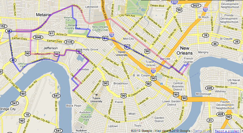


we did manage to lose our police escort at this point, only to be rejoined as we turned onto Jeff Hwy and back home via Leonidas. Jeff Parish was slightly more aggressive, but only to clear one lane of three. well, we can give them a lane.

The Dead Pelicans ride 5pm tomorrow. Dress Black, Ride Slow
-anyone have a mobile drum?

Kat is taking route suggestions. meet early, 4:30pm to talk routes.

This is only a beginning. the oil gusher won't end until the relief wells are done, probably around August. bigger and better, onward and upward.

So what are we doing for June? How can we support the demands of our rally? let's get together for planning and to contact media.

June 9th Rue on Oak and Carrollton 6:30pm
June 10th Sound Cafe 6:30pm

think floats.

ride safe!

scott


#######################

OUR DEMANDS

This a list of ten demands we are making of the federal government.

Note we are speaking to the federal government, NOT BP. BP’s chance to have any say or authority in this process should be long past. BP has proven itself a criminal enterprise concerned only with profit, recklessly and indifferently murdering its employees and the entire Gulf coast.

We demand the Federal Government intervene immediately to stop the BP Oil Flood and:

1. Declare the BP Oil Flood a national disaster so that Louisiana can finally begin getting federal assistance.

2. Stop BP’s use of “Corexit” and other chemical dispersants that present significant danger to health and safety.

3. Under a state of emergency, employ all resources (including Navy) of the government at every level – Federal, State, local, and parish — to defend our coast, our livelihoods, and our culture.

4. Suspend all BP contracts by means of the EPA’s discretionary debarment act and seize all of BP’s assets, including BP Atlantis and other operational offshore rigs, to assure that all costs of cleanup and remediation are covered.

5. Strongly enforce all regulations for workplace health and safety:
Cleanup crews must be supplied with and allowed to use full-face respirators, not paper masks.

6. Undertake immediate, full, and ongoing 3rd-party verified air-quality and toxicity testing in all affected areas, including New Orleans, and objective close monitoring of the oil leak to determine the true extent of the catastrophe.

7. End all deepwater offshore oil drilling.

8. Institute a temporary moratorium on non-deepwater offshore drilling (both current and new operations) and require each operation pass a stringent independent safety review before they can resume operation. Those that fail inspection stay shut down and are heavily fined until they comply or are debarred.

9. Keep all lawsuits related to the BP Oil Flood and its aftermath in Louisiana, and instruct the DOJ and States’ Attorney General to hold BP, Halliburton and Transocean accountable to the furthest extent possible under the law.

10. Found a two-decade TVA-Style Gulf Coast Authority that rebuilds sea walls, levees, coastlines, and wetlands, with a dedicated fund for fishermen and related industries to provide economic relief for those put out of work because of the disaster.

Tuesday, May 25, 2010

Street Bucklin' Heat, Y'all

From the nola.com feed:
http://www.nola.com/traffic/index.ssf/2010/05/five_kenner_streets_buckle_in_intense_heat.html

one wonders why we pave the GMO with materials that can't withstand the environment and compact the soil.

By Mary Sparacello, The Times-Picayune

May 25, 2010, 5:13PM

road_work.JPGAt least five locations on Kenner streets have buckled during the hot temperatures of the past four days, City Hall said Tuesday.

The Public Works Department said streets failed at:

-- 1500 38th St. near Greenlawn Terrace Elementary School
-- 661 Mayfair St. in the Holly Heights subdivision
-- 3600 Loyola Drive in University City
-- 3419 Florida Ave. in Greenlawn Terrace
-- 2400 Tifton St. in Veterans Heights.

Sunday, May 23, 2010

Banner Making this Tuesday 7pm @Nowe Miasto

No need to Drill, no need to Spill or Kill:

let's make Banners, to help set the tone for our ride this Friday, May 28th, 6pm.

We are meeting at Nowe Miasto, at the end of Jane Place, off Broad and Banks in MidCity. The time is 7pm Tuesday, the 25th.

Please bring

Bamboo
craft wire
Old Campaign Signs
White Bedsheets
Paint
Markers

or any materials that will help us construct mobile signage.

see you there!
scott
scott@nolacycle.com

Friday, May 21, 2010

TOMORROW (SATURDAY) - ANNUAL BICYCLE SECOND LINE PARADE!!!!

Twitter @mbcnola, #Bike2ndLine
---------------------------------------
http://www.mbcnola.org/SecondLine.html

WHAT: 2010 Bicycle Second-Line

WHO: Featuring the Crescent City Stompers

WHEN: Saturday, May 22nd, 2010 formation at 10:00am; departure at 10:30am

WHERE: Commencement at Magazine Street and Zoo Drive; After party at Avenger Field (Tchoupitoulas and Exposition Blvd.)


View Bicycle Second Line in a larger map

WHY: To show cycling enthusiasm for New Orleans, and learn about cycling improvements in the city

WITH: New Orleans EMS and the National Safety Council hosting a Bicycle Rodeo starting at 8am. Rodeo held at Audubon Charter School (428 Broadway). The first 50 families to either join or renew MBC will receive free helmets for their children.


View Larger Map

ALSO:
$25 for membership or membership renewal and 1 free t-shirt *note: free t-shirt is for full paying members only, not discounted student memberships
$15 for just a t-shirt, and
$5 for an existing member who wants a t-shirt

Wednesday, May 5, 2010

Link to download the latest NolaCycle poster

Last month, Scott, Rob, and I presented the NolaCycle project at the national American Planning Association Conference, hosted right here in New Orleans. Here is the link to download a copy of our poster.

Tuesday, May 4, 2010

Rim and Spoke: the River Built Everything

The River Builds Everything

The first lesson, then, to New Orleans is to forget your compass and follow the River. Uptown is the direction Upriver; Downtown is the direction Downriver. Don't move north and south, but to the River or away from the River. While you are in the city, away from the River always means toward to the Lake, Lake Pontchartrain.

You can blame all of New Orleans on the Mississippi River, because it built the soggy land we ride on. It built the streets crooked to confuse midwesterners. It built it flat so that you won't wear your knees out pedaling that beat up cruiser bike. It built it wet, so that the pavement sinks, settles, and slides at different rates, making potholes, sinkholes, and buckled pavement. It built it low so that you have take bridges to get out of town. And when we stopped it from building New Orleans, we started to lose it to the Gulf of Mexico.

Re-establishing the ecological function of the river is the only way to stave off coastal land loss and the destruction of New Orleans. Those are called Diversions, and apparently, they are also handy during incredibly bad industrial accidents, like Oil Rivers flowing at us from the Gulf bottom. The River is the cyclist's ally in the fight against fossil fuels.

Being mindful of the river and its curve can also get you where you're going faster.

For example, if you work on oak st, and live in the marigny, you might think it's easiest to ride annunciation, since you might drive tchoupitoulas (to avoid traffic at carrollton, 'natch). But if you ride that rim, it's the longest possible route--which matters for a cyclist, especially one carrying a load on her back.

There are several shorter ways than annunciation, which is probably the longest way, since it is the rim farthest from the "hub" of broadmoor. Whether or not these ways are quicker depends somewhat on your riding style, but let's examine the route length to start.

In the red, a route through the park, onto prytania. a cool 8.2 miles, but one on a well-paved, well-shaded street. If you take prytania, you won't have to make too many decisions about where to turn, but you'll take extra time getting to where you're going. And then, you usually have to bike back.

Moving closer to the hub of broadmoor, the blue line is a "Liberty" rim route, with a few more jukes to avoid one ways and bad streets. It measures around 7 miles. This is a route that takes advantage of our nolacycle data, pointing to the decenly paved streets often overlooked.

Note that all of these routes, once they hit the CBD, try to hug the "hub" of the marigny riverbend: the change in the river course means that riding close to the river as it turns away from the city is shorter than riding close to the river as it turns in.
Going nine blocks away from the river shortens the rim route by a mile. Get away from the River Uptown, hug the River Downtown into St Bernard, or when going into Metairie.


[click to expand]

The shortest rim route is a "Claiborne" route in green. Here, I tried to choose a route that would be equal in distance to the "Liberty" route. I thought it would be longer because of the long stretches spent correcting the course on spoke streets to avoid the deathly Claiborne overpass and to return to the river at the CBD. But the route closest to the hub in Broadmoor totals 6.67 miles, shorter than the Liberty route, with fewer jukes and better pavement for increased speed--it's clearly the fastest route. The traffic on Claiborne can be intimidating, but it's by no means a killer for an experienced rider.

This rule of navigation can even help you save time in a car; the highways through New Orleans are also an exception to it, as traffic managers made efforts to subvert the river-based logic that built the original grid.

Next time, we'll touch upon these "Wormholes"; where they are useful and where they can destroy you.

scott

Tuesday, April 20, 2010

Public meeting on transportation this Thursday at the Regional Planning Commission

Public input is extremely important in crafting effective planning documents. I strongly encourage everyone who cares about seeing multi-modal transportation improvements implemented to come to this Thursday.

Details from Walter Brooks at RPC:


Public Meeting - Metropolitan Transportation Plan

The Regional Planning Commission is inviting the public to participate
in a transportation planning workshop. Interested citizens are being
invited to discuss their community's transportation needs and to help
shape a better integrated land use and transportation plan for the New
Orleans region.

The RPC is currently updating the region's long-range Metropolitan
Transportation Plan (MTP) and short-range Transportation Improvement
Program (TIP). Citizens will be asked to identify their ideas for
improving the region's transportation systems as well as ways to foster
livable communities and environmental sustainability.

RPC wants to know about transportation problems, needs, or priorities in
your community. All ideas or suggested projects will be reviewed and
evaluated by RPC staff for possible inclusion in the Plan or TIP. RPC
will also provide you with the opportunity to stay informed about
transportation plans and projects that relate to your neighborhood or
community.

The workshop will be held at the Regional Traffic Management Center/RPC
offices located at 10 Veterans Memorial Blvd. in New Orleans on
Thursday, April 22, 2010 from 6:30-8:00 P.M. The building is ADA
accessible and parking is available on site. For special accommodations
for this meeting, please contact our ADA Coordinator by telephone
(504-483-8528) at least one week in advance. Upon request, RPC will
provide appropriate aids for qualified persons with disabilities so they
can participate, including interpreters for persons with limited English
proficiency.


Walter Brooks

Executive Director, New Orleans Regional Planning Commission

Monday, April 19, 2010

New Orleanians are bad at (road) diets

If you've been up on Gentilly Blvd lately, you might have noticed something different. The street is now on a diet - a road diet! This is a common traffic calming treatment "given to an urban roadway in which the number of lanes is reduced, and the freed space converted to parking, bike lanes, landscaping, walkways, or medians. Road Diets are implemented to provide additional pavement and safety for bicyclists and pedestrians, reduce speeding, and to make room for parking" (via the Streetsblog wiki).

Gentilly Blvd. through Gentilly, is now 2 lanes in each direction (instead of 3) and includes a bike lane with a striped buffer between the furthest right car travel lane and the bike lane. The idea behind the buffer is reduce the number of lanes of car traffic (since 3 was too many for how many car trips the road sees on average daily) which encourages more careful (and hopefully slower) driving behavior and reduces the number of lanes pedestrians must travel through to cross the road.

Here are some pictures I stole from Tim Eskew of Bicycle Michael's. This shows the bike lane and buffer (which changes size based on available space) at a few points along the road. Some diagonal striping has also been added in some sections, though not seen in these pictures.


Portland has started using this type of bike lane (called enhanced bicycle lanes), finding it works better than bike lanes with raised buffers or landscaped barriers (called Cycle Tracks). Here's some Q & A from the Portland Bureau of Transportation via The Oregonian about this kind of design:

What is an enhanced bicycle lane?

An enhanced bicycle lane is designed so that it provides a more protected and comfortable space for cyclists than a conventional bike lane and does not have the same barriers to sight lines as a Cycle Track - where view of cyclists may be obstructed by parked cars.

Why are we constructing enhanced bicycle lanes (i.e., what's wrong with these streets the way they are now)?

These streets currently work fine for people who are comfortable riding bicycles in mixed traffic. However, our designs are intended to make bicycling more comfortable for the majority of Portlanders who are not comfortable riding under such conditions. Our analysis indicates that most Portlanders would use a bicycle much more often than they currently do if they didn't have to mix so much with automobiles. A buffered bicycle lane provides that opportunity.

Why not use a simple bicycle lane?

Because the enhanced bicycle lane, with the added shy zones, offers a more comfortable riding environment that we believe it is more consistent with our efforts to make bicycling a part of daily life in Portland.

How does an enhanced bike lane provide more protection for cyclists than a bike lane?

Enhanced bike lanes provide more protection for cyclists by providing 'shy' or buffered zones on either side of the cyclist.

What will drivers notice that is different about driving on a street with an enhanced bike lane?

There isn't much of a change for drivers. They will still need to watch carefully for cyclists when they are turning right at cross-streets or driveways. They will also need to take care when parking on-street which is accomplished by crossing the enhanced bicycle lane. Cyclists will always be clearly visible to drivers because, unlike a Cycle Track, the buffered bicycle lane does not have the barrier of parked cars between the bicycle lane and the travel lane.

New York City cyclists are also big fans of this design, according to Streetblog New York City. A study was done finding most cyclists felt more comfortable biking on buffered lanes than non-buffered lanes.

So all in all, looks like these new buffered bike lanes should be pretty awesome for New Orleanian cyclists. Hopefully they'll encourage more people to bike instead of drive. I haven't rode them myself yet, but Jennifer Ruley at Department of Public Works has given them the first hand thumbs-up and Tim is pretty happy as well.

I did, however, drive down Gentilly Blvd today on my way back from Lakeview. I wanted to figure out how many miles it was from my house to the Fairground if I traveled St. Claude Ave. to Franklin Ave. (newly resurfaced and looking lovely - but no bike improvements, yet at least), to Gentilly Blvd. It's really not too far, considering it will allow me to avoid the insanity of Mid-City during Jazz Fest. But I saw something pretty disgusting on my way home:

Between Elysian Fields, past Franklin Avenue, I saw at least 3 cars travel in the buffered bike lane! Obviously, New Orleanians aren't really sure how to do a road diet. In all fairness, there are no signs explaining cars must stay out of the buffer zone, though anyone with a drivers license should know diagonal white strips don't equal a car travel lane. Also, I haven't seen anyone bike Gentilly the two times I've driven down it since the lane went in.

If you're biking down Gentilly Blvd., keep an eye out for cars in your bike lane! If you can, write down the plate number and report it to the police. Hopefully as more people start biking on Gentilly, less cars will try to use the bike lane as a short cut around traffic. Also, if enough people report these acts to the police, maybe they'll start monitoring the area.

New Orleans drivers are going to need more help, beyond just striping, if they're going to be successful with this new diet.


But hey, Gentilly Blvd, 4 lanes looks good on you. You we're kinda chubby back when you were a 6. I don't mean to be a jerk, but I really didn't want to go on a bike ride date with you back then. I think you look pretty hot now. Want to be my bike route?

Low-cost, one-day course in bicycle infrastructure design this Wednesday

The New Orleans Regional Planning Commission is hosting a 3-day course titled "Designing for Pedestrian & Bicycle Safety," which started today and runs until Wednesday. The first two days focus on pedestrian infrastructure, and Wednesday will cover designing for bicycles. Today's session was very informative, so I'd strongly encourage anyone interested in learning design standards and best practices to attend. (Sorry for not posting this sooner - I didn't learn about it until Sunday.)

Registration is officially closed, but if you contact Dan Jatres via e-mail (djatres@norpc.org) or phone (504-483-8505), you may still be able to reserve a spot for Wednesday's bicycle course. The cost is only $20 for public sector employees and members of community groups. If you work for a private sector firm (real estate, construction, planning, architecture, engineering, etc.), the fee is $100.

Topics to be covered at Wednesday's bicycle workshop
  • Principles of bicycling and designing for bicycling
  • On-road bikeway designs
  • Intersection design for bicycles
  • Signing and marking facilities
  • Shared use path design
Attends will receive
  • AASHTO Guide for the Development of Bicycle Facilities ($45 value)
  • Professional development credit: LAPELS, ASLA, APA
The course is designed as a professional development workshop for traffic engineers and urban planners, but students and people involved in advocacy, real estate development, architecture, and public health could really benefit from this as well. As public demand for bicycle considerations continues to build, more and more private developments will need to incorporate biking paths, lanes, and parking. Therefore, developers and architects should be familiar with basic bicycle facility design elements. Community members and public health professionals can better advocate for bicycle considerations when they understand how they are designed and built.

Thursday, April 15, 2010

Do you know how to put together and take apart a bike? Are you free this weekend?

Our friends at Contemplatives in Action need some volunteers this weekend to help put together and take apart some bikes. Jocelyn will feed you awesome homemade food for your time. If you have questions or would like to sign up, e-mail her at info@contemplativesinaction.org or call 504.891.8483.

Thanks!

Rim and Spoke: Navigating New Orleans by Bike

Welcome to a series of posts on cycling in New Orleans intended to help you navigate on two wheels. It's named after roads in the old part of town, which, when you look at a map, look like parts of your bike wheel.

There are a few types of geographical quirks to New Orleans. Some we have in common with our sister cities in southeast Louisiana--others are unique to our estuarine, industrialized metro area. There are many tricks to navigating by bicycle--especially for those of us who are small, inexperienced, or just don't want to deal with cars. I hope to introduce new cyclists, or new New Orleans cyclists to the city and its tricks so we can all ride a little lighter on our sinking roads.


Rim and Spoke

You can use these parts of your bike, the rim and the spoke, as a schematic to the older parts of the city. The city was originally designed along the French "arpent" system, which assigns lots perpendicular to the River, rather than the "township and range" system used in most cities in the U.S. as well as the newer, lower, more American New Orleans.

The Arpent system is why there are many streets that "disappear" as you ride from the River to the Lake while uptown, and many streets that come from nowhere as you ride River to Lake when downtown. Because the river meanders this way and that, the grid shifts direction. Carrollton meets Esplanade at the park, despite the fact that they both run River to Lake. Tchoupitoulas begins pointing south from Canal St, and ends up uptown pointing west into Audubon Park.


"Rim" streets are St. Charles, Claiborne, and Tchoupitoulas, (as well as Liberty, Prytania, St. Claude, and Laurel) and "Spoke" streets are Carrollton, Jefferson, and Jackson (don't forget Joseph, Leonidas, Franklin, and Washington).


As you decipher the city's curves, you can use this schema to juke around without getting disoriented if you have to avoid a familar street for the cars.

Unless you're in Broadmoor. Then you're lost.

scott eustis

Next Time: The River Built Everything
*You can learn more about this from city geographers like Craig Colton and Richard Campanella.

Saturday, April 10, 2010

No afternoon shift for mapping along the Lafitte Corridor today

Thanks to everyone to showed up yesterday, we don't have much left to map! We will be finished around 1pm today, so if you were planning on coming out from 2-6pm, you can now spend that time at French Quarter Fest or the American Planning Conference.

Thursday, April 8, 2010

Additional info about the Lafitte Corridor mapping events

Reminder: If you want to be a group leader, please meet us 30 minutes before the shift you signed up for starts. That's 9:30 am for tomorrow and 8:30 am for Saturday. The process is pretty easy, but we still need to a short time to train you on what we're doing.

Also, if you want to help update the road condition data NolaCycle collected for area (most of that was mapped between a 1 and 1 1/2 years ago), please bring your bike and a bag/backpack to carry the clipboard. For any shift with a large turn out, we'll send a few people out to do updates.

We will have some snacks, but remember to bring your own water bottle.

Monday, April 5, 2010

Location of this weekend's mapping meet-ups

Here's a lovely little map of our study area for this weekend's mapping events. We'll be mapping between Canal St. and Orleans Ave. from City Park Ave. to Basin St. The meeting locations are called out by the red placemarkers.


View Lafitte Greenway Mapping Meet-Up in a larger map