NolaCycle is a project aimed to create a high quality cycling map of New Orleans. Cycling maps include information beyond just streets and their names that benefits cyclists. In our map, we highlight the pavement quality, car travel speed, lane width, and special caution areas (busy intersections, man-eating potholes, or high accident areas). Volunteers help to collect this data by attending mapping events.
The information is then digitized to make a map of the data we collected to help cyclists - young, old, local, and tourist alike - navigate New Orleans.

Check out the blog for updates on the project, ways to get involved, and volunteer mapping events!

If you have questions, feel free to make a public comment on the blog entry or e-mail us directly at info@nolacycle.com.

Thursday, May 14, 2009

Check out Andy Menking's Local Food Map with bike routes!

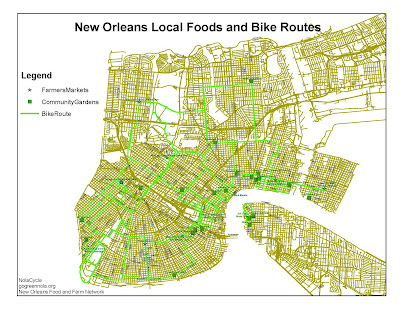
Mapping volunteer Andy Menking has used the NolaCycle date to create a bike route map in GIS connecting local food sources (farmers markets, community gardens, and a couple produce stores) to one-another (because sometimes you have to go Hollygrove and Crescent City to find all the ingredients for your weekend feast) and to the East Bank neighborhoods.

I'm really excited that our data set has been put into use even before our map is done!

NolaCycle will be working with Andy's help to build off this map to create a "Bike to the Market" map for the Crescent City Farmers market this summer. Keep posted and look for it around later July or August!

No comments:

Post a Comment